Version 1.0, February 1, 2002
EORC, NASDA / RESTEC
Table of Contents
- Introduction
- Format of Raw Data
- Data Division and File
- Data Processing
- Data Utilization and Redistribution
Contact Point
1. Introduction
This global data set processed from NASDA's
Ocean Color and Temperature Scanner
(OCTS) onboard the Advanced
Earth Observing Satellite (ADEOS). The data set
was produced in the research project "Development of a precise
geometric correction technique
and the production of a satellite data set," which
is part of the "Global Carbon Cycle and Related
Mapping Based on Satellite Imagery (GCMAPS) program"
founded by the Ministry of Education, Culture, Sports, Science and
Technology of Japan.
To Contents
2. Format of Raw Data
To Contents
3. Data Division and File Name
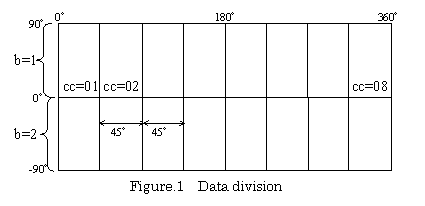
3.1 Data Division
It is set to 1.6GB per file in the carbon circulation database.
Therefore, data was divided on Web to the size (about several MB) which can be downloaded.
First, divided for every channel. Furthermore, divided the earth into 16,
divided into 2 in the direction of north and south
and divided into 8 in the direction of east and west (Figure.1).
The data size after division is as follows.
1.6 (GB) / 16 (ch.) / 2 (byte integer) / 8
To Contents
3.2 File Name
The file name of each data after division is as follows.
com_xxdy.aabcc
To Contents
4. Data Processing
4.1 Data Processing Procedure
This data set was generated based on the following procedure.
| (1) Radiometric Correction |
- Calculation of coefficients
- Conversion from digital number to radiance or brightness temperature
- Elimination of stripe noise
|
| (2) Geometric Correction |
- Automatic GCP collection
- Modification of satellite position and attitude
- Calculation of geolocation of observed points
- Resampling image data onto map coordinates
|
| (3) Composite |
- Separation to four areas
- Selection of cloud-free data
|
To Contents
4.2 Radiometric Correction
The band image in OCTS Level 1A data is described as an observed
digital number (DN), and OCTS has an Ocean/Land gain mode and
Tilt/Non-tilt mode. Therefore, data should be corrected radiometrically.
For visible and near infrared bands, The DN was converted to radiance
(mW/cm2/sr/micrometer) by using coefficients
calculated for each condition of the observation (tilt angle, gain,
temperature) line by line. In thermal infrared bands, a black body
was observed for each scan. The DN could be converted to radiance
(mW/cm2/sr) by using blackbody data. The radiance was converted
to brightness temperature (K) using a look-up table included in the level 1A
data. A de-striping process was applied for both visible and thermal bands.
To Contents
4.3 Geometric Correction
An OCTS product contains the geolocation data (Latitude/Longitude)
of observed points derived by a systematic correction method. A
comparison of these data with corresponding locations on the image revealed
an error of a few kilometers on the ground. Therefore, accurate geometric
correction utilizing ground control points (GCP) was applied to
make composite images.
The GCPs are automatically extracted by a image-matching method
using image data and coastal line data prepared in advance. The
satellite position and attitude are modified based on the principle
of photogrammetry. The subsequent procedure is the same as
systematic correction.
To Contents
4.4 Composite
Cloud-free composite data were generated from radiometrically and
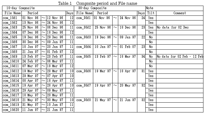
geometrically corrected data. Basically, the period for composite data
is 30 days. However, since OCTS was operated in the non-tilt mode for
three months from Dec.19, 1996, we set the composite period flexibly.
The eight generated images of the 30-day composite data as shown
in table below.
The cloud-free composite algorithms are different for four areas:
ocean, high latitude; ocean, mid-low latitude; land, high latitude;
and land, mid-low latitude. The distinction between ocean and land was
made based on the land mask data. Latitude was distinguished by whether
solar zenith angle (SZA) exceeded the threshold of 1.35 radians or not.
The algorithm for each area is shown below.
Ocean, high latitude
Select the pixel with the minimum value in band 5.
Ocean, mid - low latitude
Select minimum band 5 within the scenes that have SZA below the
threshold.
Land, high latitude
Select minimum band 11 from scenes with saturated band 7, and
select the minimum SZA scene from scenes with unsaturated band 7. Select
the larger band 11 from these two scenes.
Land, mid - low latitude
Select the minimum band 5 scene from saturated band 7 scenes,
and select the maximum Normalized Difference Vegetation Index (NDVI) from
the scenes with unsaturated band 7. Finally select the larger band 11 scene.
To Contents
4.5 References
- NOAA, 1997, NOAA GVI GUIDE, on
http://www2.ncdc.noaa.gov/docs/gviug/
- T. Hashimoto, "Precise geometric correction of ADEOS/OCTS imagery,"
Journal of the Japan Society of Photogrammetry and Remote Sensing,
vol.36, no.5, pp.42-51, 1997. (in Japanese)
- T. Hashimoto, "The estimation of motion and attitude of ADEOS satellite
utilizing the principle of exterior orientation," Journal of the Japan
Society of Photogrammetry and Remote Sensing, vol.37, no.6, pp.4-13,
1998. (in Japanese)
- T. Hashimoto, T. Igarashi, A. Mukaida, R. Higuchi, "Global Image
Composite of ADEOS/OCTS GAC Data," Proc. of 21st Asian Conference
on Remote Sensing, pp.152-157, 2000.
To Contents
5. Data Utilization and Redistribution
5.1 Copyright, exemption from responsibility, and redistribution
The National Space Development Agency of Japan (NASDA) reserves copyrights
of all data downloaded from this homepage. NASDA is not responsible for
any trouble caused by using this data set. The redistribution of
this data set (in whole or part) is permitted only if this README file is
attached.
5.2 Credit
The data downloaded from this homepage is for scientific use only. Anybody wishing to
publish any results using the data downloaded from this homepage should clearly
specify the credit ((c) National Space Development Agency of Japan or
(c) NASDA) beside the image or acknowledge the source of the data
in the publication.
Example: The OCTS data utilized in this study is provided by
National Space Development Agency of Japan (NASDA) as part of the
"Global Carbon Cycle and Related Mapping Based on Satellite Imagery:
GCMAPS program" of "Research Project by the Special Coordination
Funds for Promoting Science and Technology" funded by the Ministry of
Education, Culture, Sports, Science and Technology of Japan (MEXT).
To Contents
Contact Point
Earth Observation Research Center
National Space Development Agency of Japan
Office Tower X-23F, Harumi Island Triton Square,
1-8-10, Harumi, Chuo-ku, Tokyo 104-6023 Japan
Phone: +81-3-6221-9000 (Rep.)
Fax: +81-3-6221-9191
E-mail: helpdesk@eorc.nasda.go.jp
URL:
http://www.eorc.nasda.go.jp
To Contents