 by
email.
by
email.
The purpose of this service is to distribute the ADEOS OCTS
Level 3 Map (RTC, LAC) Data via the Internet.
For the present, we distribute the OCTS Level 3' (Near Real Time) Data just around Japan, extracted from 11 fixed area, and we are planning to add various data one by one.
Since this service is still experimental, the specifications might be changed without notice.
Please send your comments to
by
email.
ADEOS OCTS/RTC Level3' Map SST (Sea Surface Temperature)
ADEOS OCTS/RTC Level3' Map OCR/C (Chlorophyll-a concentration)
SST(K) is to be computed where:
| Scaling | linear |
| Scaling Equation | (Slope * 13m_data) + Intercept = T |
| Slope | 0.150000 |
| Intercept | 271.1500 |
| Units | kelvin |
The concentration of Chlorophyll-a (mg m^-3) is to be computed where:
| Scaling | logarithmic |
| Scaling Equation | Base ** ((Slope * 13m_data) + Intercept) = C |
| Base | 10.000000 |
| Slope | 0.015000 |
| Intercept | -2.000000 |
| Units | mg m^-3 |
These area are defined by NASDA EORC and EOC.
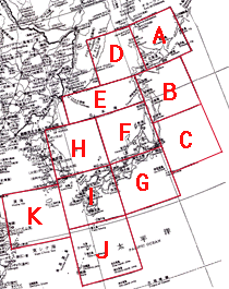
| Left-Top of rectangle | Right-Bottom of rectangle | |
| Longitude, Latitude | Longitude, Latitude | |
| A | 141.900000,47.050000 | 148.150000,42.600000 |
|---|---|---|
| B | 140.250000,42.600000 | 146.499000,37.808000 |
| C | 140.250000,37.800000 | 146.499000,32.680000 |
| D | 135.650000,47.050000 | 141.900000,42.600000 |
| E | 130.870000,42.600000 | 140.250000,40.600000 |
| F | 134.000000,40.640000 | 140.250000,35.665000 |
| G | 134.000000,35.700000 | 140.250000,30.443000 |
| H | 127.740000,40.640000 | 134.000000,35.665000 |
| I | 127.740000,35.700000 | 134.000000,30.443000 |
| J | 127.740000,30.450000 | 134.000000,24.894000 |
| K | 121.490000,34.500000 | 127.740000,29.171000 |
We distribute 6 files per 1 scene as follows:
(e.g.)
| AByymmddPPPSDZ.gif | full scene image (GIF) |
| AByymmddPPPSDZ.dat | extracted sub-scene data (plain raster) |
| AByymmddPPPSDZ.jpg | extracted sub-scene image (jpeg) |
| AByymmddPPPSDZ.ppm | extracted sub-scene image (ppm) |
| extAByymmddPPPSDZ.log | parameters to calculate pixel values from
lat.-lon. |
| AByymmddPPPSDZ.log | original global attribure informations (text) |
| A | : | Data Type (RTC = R , LAC = L) |
| B | : | Product Type (SST = S , OCC = O) |
| yymmdd | : | Observation date |
| PPP | : | RSP Path number |
| S | : | Segment number |
| D | : | Dummy |
| Z | : | Scene Type (full = Y , extract = X) |
/** extAByymmddPPPSDZ.log **/
(e.g.)
| Area:A | Extracted Area |
| (141.900000,47.050000)- | Lat.-Lon. of the left-top of the
rectangle |
| (148.150000,42.600000) to | Lat.-Lon. of the right-bottom of the
rectangle |
| ( 2886, -698)- | Pixel-Line of the left-top of the rectangle |
| ( 3910, 324) | Pixel-Line of the right-bottom of the rectangle |
| size 1024x1022 | Size of the extracted area |
| in | Inside of the area |
| out | Outside of the area; the data could not be extracted |
/** AByymmddPPPSDZ.log **/
Please refer to the OCTS Data Format Descriptions for the
contents of the files.
You can visualize plain raster data with following tools:
(e.g.)
| UNIX: | netpbm (Free) |
| MAC: | Photoshop (Commercial Product) |